-

Topographic / Mapping
✅ Contour Lines – Elevation changes, spaced based on terrain steepness.
✅ Elevation Data – DSM (Digital Surface Model) or DTM (Digital Terrain Model).
✅ Orthomosaic Imagery – High-resolution aerial image overlay for reference.
✅ Point Cloud Data (LAS/LAZ) – 3D modeling and volume calculations.
✅ Stockpile & Cut/Fill Analysis – Construction, mining, and excavation projects.
✅ Drainage & Slope Analysis – Environmental and engineering assessments.Aerial Image Base Layer – Orthomosaic from the drone.
Contour Lines (Vector Layer) – Extracted from DSM/DTM.
Colorized Elevation (Raster Layer) – Gradient shading to visualize height.
Point Cloud (3D View) – accurate terrain modeling.
🔹 Construction & Earthworks – Volume calculations, cut/fill analysis.
🔹 Mining & Aggregates – Stockpile volume, terrain stability.
🔹 Agriculture & Forestry – Drainage patterns, crop analysis.
🔹 Environmental Surveys – Land use planning, erosion detection. -

High Precision Inspections / Monitoring
✅ Construction & Earthworks – Site monitoring, volume calculations, and progress tracking.
✅ Mining & Aggregates – Stockpile measurements, cut/fill analysis, and site mapping.
✅ Agriculture & Forestry – Crop health monitoring, terrain analysis, and yield estimation.
✅ Energy & Utilities – Powerline, solar farm, and wind turbine inspections.
✅ Infrastructure & Transportation – Bridge, highway, and railway inspections.
✅ Oil & Gas – Pipeline monitoring, leak detection, and safety compliance.
✅ Real Estate & Insurance – Aerial property inspections, roof assessments, and damage surveys.
✅ Environmental & Land Management – Floodplain mapping, erosion detection, and habitat monitoring.Solutions You Can Provide with the Mavic 3 Enterprise
🔹 High-Resolution Mapping & Surveys
Create 2D orthomosaics and 3D models for site assessments.
Accurate terrain mapping with RTK support.
Export deliverables in GeoTIFF, LAS, DXF, or Shapefiles for GIS/CAD.
🔹 Stockpile & Volume Measurements
Track material movement for quarries, mining, and construction sites.
Provide cut/fill analysis for excavation projects.
🔹 Infrastructure & Asset Inspections
High-resolution zoom for inspecting bridges, towers, and buildings.
Thermal imaging (if using Mavic 3T) for heat leaks, electrical faults, and solar panel efficiency.
🔹 Vegetation & Environmental Monitoring
NDVI analysis (with multispectral sensors) for agriculture.
Detect invasive species, erosion, and land-use changes.
🔹 Roof & Structural Inspections
Identify damage, missing shingles, and leaks for insurance claims and real estate.
Capture high-resolution images safely and quickly.
🔹 Search & Rescue / Emergency Response
Thermal (M3T) can detect missing persons or heat signatures.
Provide fast aerial overviews for disaster response.
-

Construction and Excavation Solutions
Enable high-value solutions that improve efficiency, accuracy, and cost savings.
✅ Faster Data Collection – A 30-minute drone flight can replace days of manual surveying.
✅ More Accurate Results – High-resolution drone data reduces human error.
✅ Cost Savings – Eliminates expensive ground surveying teams.
✅ Improved Safety – No need for personnel in hazardous zones.Progress Monitoring & Site Documentation
🔹 Aerial Progress Reports – Regular flights to capture site changes over time.
🔹 High-Resolution Orthomosaics – Detailed maps for project tracking.
🔹 Time-Lapse Aerial Views – Show how work is progressing for stakeholders & investors.🚀 Solution: Deliver high-resolution before-and-after images and 3D models to track construction milestones.
Stockpile & Volume Measurements
🔹 Material Inventory Tracking – Measure stockpile volumes for aggregates, sand, and soil.
🔹 Cut & Fill Analysis – Compare excavation vs. fill areas for earthworks planning.
🔹 Reduce Material Waste & Theft – Monitor and audit material movement without manual surveys.🚀 Solution: Precise volumetric reports to help manage material costs.
Site Planning & Pre-Construction Surveys
🔹 Digital Terrain Models (DTM) – Map existing topography for site grading & design.
🔹 Elevation & Slope Analysis – Identify potential issues before breaking ground.
🔹 Drainage & Erosion Control – Analyze how water flows across a site.🚀 Solution: Accurate terrain maps and elevation models to assist engineers & project managers.
4. Safety & Compliance Inspections
🔹 Hazard Identification – Detect unstable ground, trench collapses, or unsafe zones.
🔹 Site Perimeter Monitoring – Check fence lines, barriers, and restricted areas.
🔹 Regulatory Compliance – Ensure sites follow environmental and safety regulations.🚀 Solution:Real-time aerial inspections to help improve job site safety.
Heavy Equipment & Asset Tracking
🔹 Monitor Equipment Usage – Ensure machines are used where they should be.
🔹 Prevent Unauthorized Use – Track movement and prevent theft or misplacement.
🔹 Fleet Optimization – Identify idle or underutilized machinery to reduce costs.🚀 Solution: Provide real-time aerial views of equipment placement and usage to optimize operations.
Foundation & Structural Assessments
🔹 Monitor Excavation Depths – Ensure correct grading and excavation compliance.
🔹 Detect Structural Defects – Identify cracks, misalignments, and weak points.
🔹 Thermal Inspections (if using M3T) – Detect water leaks, insulation issues, and subsurface anomalies.🚀 Solution:Verify foundations and structures without manual inspections.
As-Built Surveys & BIM Integration
🔹 3D Modeling for As-Built Documentation – Capture real-world conditions vs. blueprints.
🔹 Overlay Drone Data onto BIM Software – Compare planned vs. actual site conditions.
🔹 Reduce Rework & Improve Accuracy – Ensure projects stay on track with minimal errors.🚀 Solution:3D data and Orthomosaic overlays for better decision-making in CAD & BIM tools.
-

Marketing Media Production
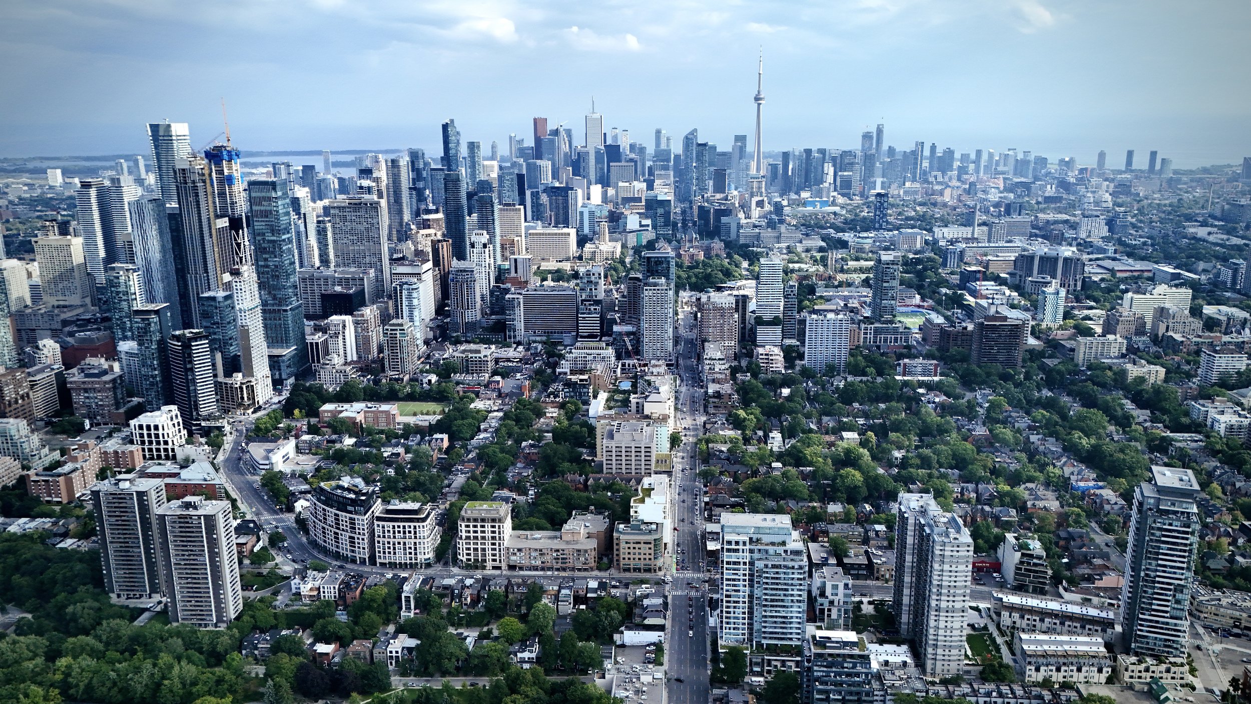
We specialize in creating high-impact marketing media tailored for large-scale projects and industrial developments. Our expertise lies in capturing the scale, complexity, and dynamic progress of major operations through advanced aerial photography, high-resolution videos, and time-lapse sequences.
Key Features:
Project-Focused Storytelling: Showcase construction milestones, infrastructure growth, and development timelines with compelling visuals.
High-Resolution Aerial Imagery: Provide sweeping views of expansive sites, highlighting key project elements and progress.
Dynamic Time-Lapse Videos: Capture long-term project evolution, offering stakeholders a clear visual narrative of advancements.
Engaging Promotional Content: Create tailored media for presentations, marketing campaigns, and stakeholder engagement.
Industrial and Commercial Focus: Our services are designed specifically for large-scale projects, not residential real estate, ensuring specialized content that meets professional industry standards.
With Four Points’ Marketing Media Production, your projects are presented with precision, professionalism, and visual impact that resonates with audiences across industries.
-

Reality Capture Services
Our Reality Capture services provide highly accurate, data-rich 3D models and digital twins that enhance decision-making across industries. By utilizing advanced photogrammetry and LiDAR technologies, we transform physical environments into precise, measurable digital assets.
Key Benefits:
Precision and Accuracy: Achieve centimeter-level detail with RTK-enabled data, minimizing errors in planning and construction.
Enhanced Visualization: Create immersive 3D models and time-lapse visuals for progress tracking, presentations, and stakeholder engagement.
Data-Driven Insights: Gain actionable insights from detailed point clouds and Orthomosaics, supporting design, analysis, and quality control.
Efficiency and Cost Savings: Reduce site visits, manual surveying time, and rework through comprehensive digital documentation.
Versatile Applications: Ideal for construction, real estate, infrastructure inspections, agriculture, and environmental monitoring.
With Four Points’ Reality Capture, you’re not just documenting spaces—you’re unlocking a new dimension of data-driven possibilities.